 |
Sightseeing in Estonia. County of Valgamaa
|
|
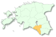
The County of Valga (2046 sq km, population about 40,000) is in the central part of South Estonia, between Lake Võrtsjarve and the Latvian border. The County-centre Valga together with the Latvian town of Valka creates a peculiar double-town, with the State border running through the towns. The County of Valga is one of the few counties of Estonia were numerous local and international level sporting competitions are organised all year round and cultural entertainment is provided for all tastes. The hilly landscape of the County of Valga with over 200 lakes offers excellent opportunities for camping and holiday making. The most interesting sights of Valga County :1. The Otepää Nature Park covers the 232 sq km area of dome hills and many lakes in the North-Eastern part of the County of Valga. Due to the varied landscape, lots of water bodies and snow in wintertime Otepää is an excellent place for summer and nature holidays; the Estonian Skiing Center is also located here. Lake Pühajarv, situated in the Otepää Nature Park, is the biggest and most beautiful lake of the Otepää Upland - the lake is 3.5km long, 1.6km wide and up to 8.5m deep. You can discover the nature and culture of the surrounding area of Lake Pühajarve on many walking trails of different lengths. 2. The Otepää Church, where in 1884 the blue-black-white flag of the Estonian Students' Society was consecrated, is the oldest building in the town. This historical event took place in Kirikumõisa. In 1922 the flag became a flag of nation and later the national flag of Estonia. In the park of Kirikumõisa there is a monument to Jakob Hurt, a collector of folklore and the first Minister of Estonian nationality in the Church of Otepää. The Ski Museum and Flag Museum are also located in the Pastorate. On the Otepää Town Hill there was an ancient stronghold of Estonians, which was easy to protect due to its good natural location. The exact date of the stronghold is unknown, but it was already the most important stronghold of the Ancient Ugala a thousand years ago. Now you can see and touch the ruins of a stone stronghold, built on the initiative of the Bishop Herman in 1224. 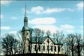
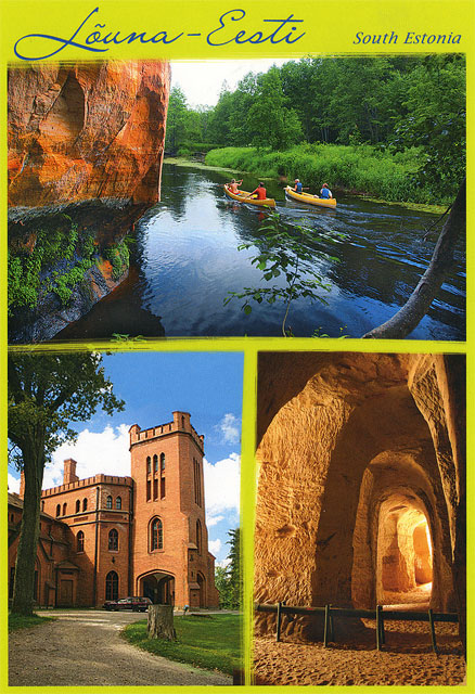
3. The effort of climbing to the top of the Mount Väike-Munamägi pays off many times over. The view that opens from the top covers more than 50km. On the Northeastern slope of the Mount Väike Munamägi there is a spring that is historically considered to be the source of the River Väike-Emajõgi. From here a small brook rills down the valley and disappears into the ground and comes up again down on the meadow, joining the brook that flows into Lake Pühajärve in the Southeastern end of the Park. 4. The Observation Tower of Harimäe is situated 3km from Kaariku towards Sangaste. The Hill of Harimägi, also known as the Leenard Hill and Leonhard Hill is one of the biggest flat-topped hills of the Otepää Upland; according to the latest measurement - 211.3 meters over the sea level. This oblong elevation runs in a Northeastern-Southwestern direction for more than 2km. The Southwestern part is the highest part (211.4m). In 1816-1819 geodetical measurements were made by the internationally famous astronomer Friedrich Georg Wilhelm Struwe (1793-1864). During the measuring a triangulation tower was erected on the Hill of Harimägi, of which only the stone foundation has been preserved until today. Harimägi is well worth visiting if you in the region of Otepää. In 2003 a 28m high wooden Observation Tower of Harimäe was opened; the highest observation platform is at the height of 24 meters. 5. Sangaste Castle is 25 km from Otepää and it was built in 1874 -1881. The red-brick building with beautiful halls, surrounded by a nice park and ponds is a an unforgettable place. The last owner of the Sangaste Manor Friedrich Magnus Berg is also known as a breeder of a high yielding winter hardy variety of rye. You can see many rare trees in the Castle Park, many of which, in Estonia, can be found only in Sangaste. 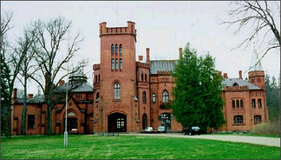
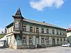
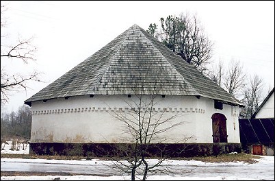
6. Hellenurme Watermill a grand watermill situated on the shore of a scenic reservoir, was built from red bricks and land stones in the 1880s by the landowning Mittendorff Family. The furnishings, i.e. flour and groats production equipment date mostly from the 1930s. The four and a half storied mill is in working order and shows how people could come with one bag and leave with seven. A hydroelectric power station is also in operation here. 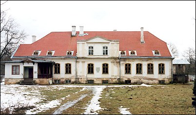
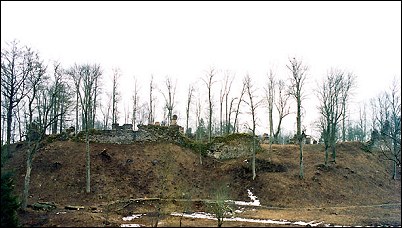
7. The Ruins of the Stronghold of Helme remind us of the old days. The Stronghold, which was built on the first half of the 14th century on a hill slope, located between two natural valleys, stood here for more than three centuries. Under the Stronghold is the Spring Ohvriallikas or Arstiallikas, where young maidens used to sacrifice beads for their beauty. North of the Stronghold are the Helme Caves, (also called Hell) that were dug as a refuge probably even before the ancient fight for freedom. The main sights of the Helme Caves are the two halls. The first hall is a room with vaulted ceiling of a diameter of 3.5 x 6m and the height of 3.5m. The second cave hall that has been preserved is almost round room with a diameter of 5.5m and with a height, which allows you to stand up freely. 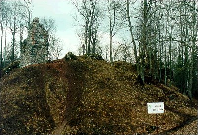
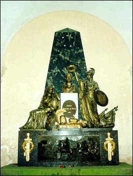
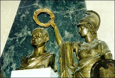
8. In the Manor of Jõgeveste the famous Russian Commander Field Marshal M. A. Barclay de Tolly spent his last years. In the Barclay de Tolly Mausoleum there are the sarcophaguses of the Count and Countess Barclay de Tolly, a Classicist-style pyramid-shaped gravestone, the bust of the Commander and a relief depicting the Russian Army. 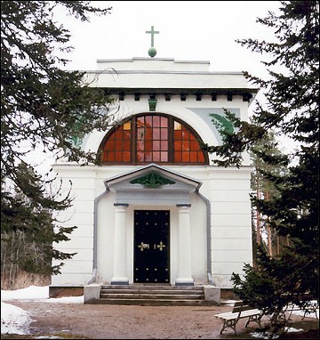
9. Taagepera Manor Building (built in 1907-1912) is a real castle. Taagepera Castle is one of the most impressive Jugendstil buildings in Europe. The architect of the building was Otto Wildau. In addition to the Castle the other interesting parts of the Manor Complex are the gate building, stables built from land stones, a watermill and a beautiful park. 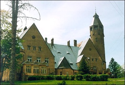
10. Karula National Park, situated in the Counties of Valga and Võru, has an area of 10,300 hectares. The upland landscape of Karula is varied, pure and untouched. The domes covered with forests and meadows are located side-by-side or are more scattered. Between them are bogs, bog forests, lakes and brooks. There is very rich avifauna in Karula. While hiking in the forests you can meet roe deer, elks, European deer, wild boars, foxes, wolves, raccoon dogs, otters, lynx, hares, ondatras and other smaller animals. In many places the signs of beaver's activities can be seen. From the Karula Visitors' Center (the Village of Ahijärve, the Parish of Antsia) the traveler could obtain information about the Nature Park and its hiking trails. 
|
MY PHOTOS |